
Tired of delays, rework, and blown budgets?
Most construction issues comes from one thing:
inaccurate or outdated data.
At Stefan Engineering, we deliver laser-focused, survey-grade data so your projects run smoother, faster, and on budget.
Our Core Services


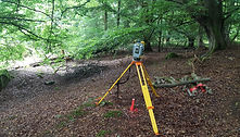
Site Engineering / Construction Setting Out
Drone Surveys
Precision setting out for any construction element - from foundations and anchor bolts to steel frames and infrastructure.
Fast, accurate, and aligned with your project drawings.
Fast, cost-effective aerial mapping using drones. Whether it's land development, planning, or earthworks, our drone surveys deliver accurate georeferenced data in days - not weeks.
Topographical Surveys
Detailed land surveys using GNSS, total station, and drone photogrammetry. Ideal for planning applications, drainage, design, and site assessment.
Why Choose Stefan Engineering
-
Over 20 years experience in civil, oil & gas, and infrastructure
-
Member of Chartered Institution of Civil Engineering Surveyors
-
Based in Glasgow, working across Scotland
-
Trusted by construction companies, developers, and consultants
-
Flexible site visits, fast turnaround, and ongoing support
Testimonials
.png)
Paul Mitchell
Site Manager
Kelburne Construction
“I want to say thank you for Stefan Niculescu's efforts in assisting the successful completion of the Car Park at Forth Valley Hospital.
His use of the latest survey equipment certainly helped get the Car Park completed on time and I am certain the earthworks contractor felt the same."
_edited.jpg)
John Mcdonough
Project Manager
Zenith SAS
“From the beginning, Stefan Niculescu demonstrated a thorough understanding of the project requirements and exhibited an constant commitment to accuracy and precision. He set out precisely the construction site and provided reliable dimensional control, ensuring the proper positioning and alignment of the ground flare system."

Ben Tichy
Project Manager
Track Engineering Services
Stefan is my former colleague, who’s been always pleasure to work with and now when I’m a Project Manager in railway engineering consultancy and we were short of people for some projects, I didn’t need to think twice who to ask for an assistance. Excellent technical knowledge, outstanding problem solving skills and can do attitude, I can only recommend his services.


Frequently Asked Questions
What services does Stefan Engineering offer?
Stefan Engineering is dedicated to providing exceptional surveying and engineering services. Our comprehensive services include setting out, levelling, as-build surveys, producing detailed digital terrain models (DTMs), machine control setup, volume calculations, topographical surveys, laser scanning, dimensional control, and monitoring surveys.
What experience does Stefan Engineering have in the industry?
The business founder, Stefan Niculescu, brings almost two decades of experience as a Site Engineer and Land Surveyor to the business. Throughout his career, he has worked on a diverse range of projects in the Construction, Oil & Gas and Mapping industries making Stefan Engineering a trustworthy choice for your project needs.
How does Stefan Engineering ensure accuracy and precision in its services?
Stefan Engineering prioritizes accuracy and precision. We meticulously survey and produce plans, drawings, and calculate quantities, ensuring the highest quality results. Our team uses advanced technology and methods to ensure precise topographical surveys, laser scanning, dimensional control, and monitoring surveys.
How can drone mapping and 3D modelling improve my project outcomes?
At Stefan Engineering, we leverage the power of drone mapping, 3D modelling, and volume calculations to enhance project outcomes. By using these advanced technologies, we can provide a comprehensive, detailed view of your project site, facilitating better decision-making and resulting in significant time and cost savings for our clients.
How does Stefan Engineering's services lead to cost and time savings?
By leveraging advanced technologies like drone mapping and 3D modelling, we can quickly gather detailed, accurate data. This results in improved project management, reduced on-site time, less rework due to errors, and hence, significant cost and time savings.
Why should I choose Stefan Engineering for my geospatial and surveying needs?
Choosing Stefan Engineering means choosing decades of industry experience, a commitment to accuracy and precision, and a dedication to successful project outcomes. We combine advanced technology with industry know-how to deliver services tailored to your project's specific needs, improving efficiency and ultimately saving you time and money.
How do I get started with Stefan Engineering?
Getting started with Stefan Engineering is simple. Contact us today for a free consultation. We'll discuss your project requirements, provide expert advice, and offer a competitive quote for our services. Let Stefan Engineering guide your project to success.